Reading a Topographic Map
What a topo map shows and how to read it: map colors, scale and the 1:24,000 quad, contour lines and the contour interval, index contours, steep versus gentle ground, and the shapes of hills, saddles, valleys, ridges, and depressions, with Driftless and Northwoods examples.
- 4 min
- 6 steps
- 3 questions
- Lesson 37 of 49
In this lesson
- What a topo map shows
- Scale
- Contour lines
- Five shapes
- Try it
- What to take from this
Picking up where you left off.
What a topo map shows
A topographic map’s defining feature is contour lines, which show the shape of the land. It also carries symbols for roads, buildings, streams, and vegetation 1. USGS colors follow a scheme 1:
- Brown: contour lines.
- Blue: lakes, streams, and other water.
- Green: vegetation, woods.
- Red: land survey grids and important roads.
- Black: other roads and trails, railroads, boundaries, buildings.
- Purple on older maps: revisions made from aerial photos.
Point symbols mark buildings, campgrounds, springs, mines, and survey markers, and names are printed in the color of the feature they label 1.
Scale
The standard USGS topo is the 7.5-minute quadrangle at 1:24,000: 1 inch on the map is 24,000 inches, or 2,000 feet, on the ground, and about 2.6 inches make a mile. Each quad is named for a feature on it. The bar scale in the margin is the safest way to measure distance; mark a scrap of paper’s edge against the route, then lay it on the bar scale.
Quick check
24,000 inches is 2,000 feet; about 2.6 inches make a mile.
Contour lines
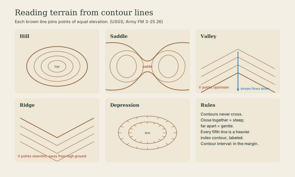
Each contour joins points of equal elevation, so contours never cross. Every fifth line is a heavier index contour with its elevation printed on it; the lighter ones between are intermediate contours. The contour interval, the height between neighboring lines, is printed in the margin: 10 feet or less on maps of flat country, 100 feet or more in mountains 1.
- Lines close together: steep ground.
- Lines far apart or absent: gentle or level ground 1.
- Count lines between two points and multiply by the interval to get the height difference.
Quick check
Widely spaced or missing contours mean gentle or level ground.
Five shapes
From the Army’s land navigation manual 2:
- Hill: concentric closed contours; the smallest ring is the top. From a hilltop, ground slopes down in every direction.
- Saddle: a low point between two higher areas, drawn as an hourglass. Stand in a saddle and you have high ground in two opposite directions and low ground in the other two.
- Valley: a long groove, usually with a stream. Its contours form U or V shapes whose closed end points upstream, toward higher ground.
- Ridge: a sloping line of high ground; its U or V contours point away from high ground, downhill.
- Depression: a hollow or sinkhole, drawn as closed contours with tick marks pointing toward low ground.
Smaller features use the same logic: a draw is a small valley with Vs pointing uphill; a spur juts from a ridge with Vs pointing downhill; a cliff shows as contours merging or touching 2.
In Wisconsin: the Driftless Area’s coulees are textbook valleys and spurs, with tightly packed contours on the bluffs and Vs marching up every side coulee. Up north, glacial country reads differently: low hills (drumlins and moraines) and countless closed depressions, many holding lakes and bogs. Check the interval in the margin: on gentle glacial ground a few lines can mean a lot.
Playback is optional. If the player is unavailable, open the video at its source.
Quick check
On a ridge or spur, the Vs point the other way: downhill, away from high ground.
Try it
Print the USGS quad for a place you know well (they’re free from the USGS store or The National Map). Find your house or a familiar trail, then trace one route with your finger and say aloud what the ground does: up a spur, across a saddle, down a draw to a creek. Walk it and check.
What to take from this
Topo maps show land shape with brown contour lines of equal elevation, plus colored symbols: blue water, green woods, red grids and main roads, black other features. On a 1:24,000 quad, 1 inch is 2,000 feet. Contours never cross; every fifth is a labeled index line; the interval is in the margin. Close lines are steep. Hills are rings, saddles hourglasses, valley Vs point upstream, ridge Vs point downhill, and depressions have inward ticks.
Lesson complete
Nice work.
Sources for this lesson
- 1Topographic Map Symbols. U.S. Geological Survey. verifiedContours join points of equal elevation and never cross; brown contours, wider labeled index contours, closer lines mean steeper slopes; contour interval printed in the margin, 10 ft or less in flat country; colors: green vegetation, blue water, red land grids and major roads, black other roads, trails, and boundaries; purple was a former revision color.
- 2FM 3-25.26 Map Reading and Land Navigation. Headquarters, Department of the Army. 2005. verifiedTerrain features in contours: hill, saddle (hourglass), valley (closed end of U or V points upstream), ridge (points away from high ground), depression (tick marks to low ground), draw, spur, cliff; pace count: about 30-in. pace, count per 100 m on similar terrain, longer downhill and shorter uphill or in snow; deliberate offset about 10°, 18 m per degree per 1,000 m; bypassing obstacles at right angles; handrails, catching features, attack points within 500 m; shadow-tip method (first mark west, wait 10-15 minutes); watch method; Polaris less than 1° from true north, found by the Big Dipper's pointers at five times their spacing.