How Glaciers Made Wisconsin
The last ice sheet's visit to Wisconsin, from its advance about 31,500 years ago to its retreat from the north about 11,000 years ago, the six lobes, and how to read what it left: drumlins, eskers, moulin kames, end moraines, outwash, and kettles, with the Kettle Moraine as the textbook.
- 5 min
- 7 steps
- 3 questions
- Lesson 1 of 49
In this lesson
- The last ice sheet
- Under the ice
- At the stagnant edge
- At the ice front
- Beyond the ice front
- Try it
- What to take from this
Picking up where you left off.
The last ice sheet
Wisconsin is named in the textbooks of geology: the last glacial stage of North America, the Wisconsinan, takes its name from deposits here 1. The ice sheet that made them was the Laurentide, spreading south from Canada.
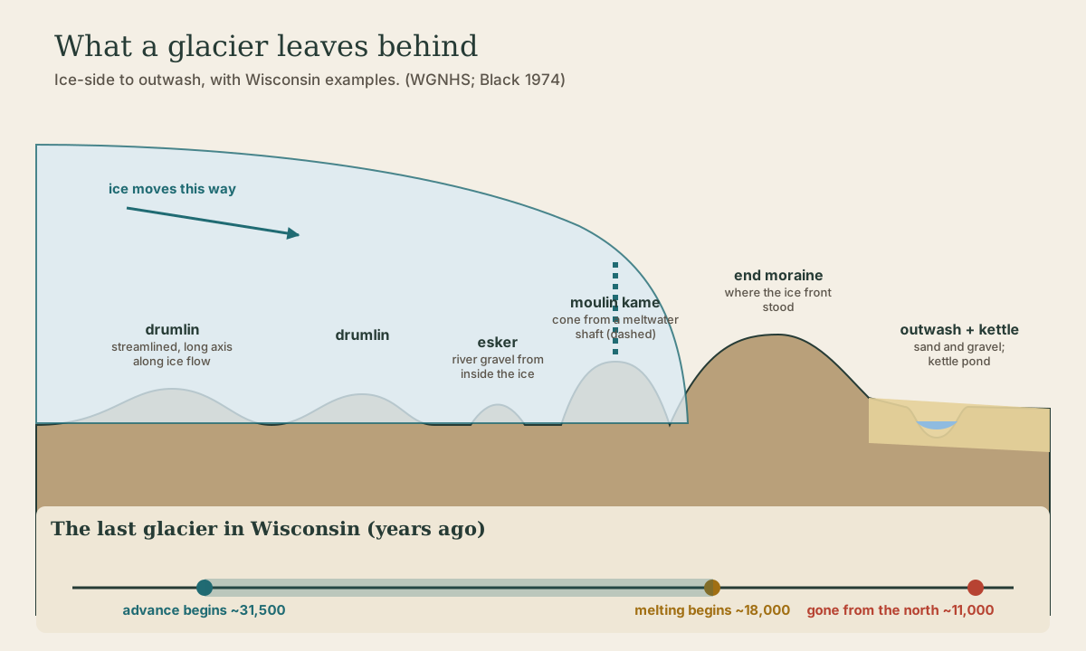
The Wisconsin Geological and Natural History Survey gives the timeline 2:
- About 31,500 years ago, the glacier began advancing into Wisconsin, and it kept expanding for 13,500 years.
- About 18,000 years ago, the climate warmed and the ice started to melt back.
- It took another 7,000 years to leave northern Wisconsin, about 11,000 years ago.
The ice moved as lobes, tongues that followed lowlands: the Lake Michigan and Green Bay lobes in the east, and the Langlade, Wisconsin Valley, Chippewa, and Superior lobes across the north 2.
“The many lakes and wetlands and the irregular landscape that characterize so many areas of eastern and northern Wisconsin are also a direct result of the last glacier” 2.
Quick check
It began advancing about 31,500 years ago and started melting back about 18,000 years ago.
Under the ice
- Ground moraine: the blanket of till (unsorted clay, sand, and boulders) the ice smeared across the land beneath it 1.
- Drumlins: streamlined hills of drift, molded by moving ice into the shape of a long half-egg, steepest and highest toward the end the ice came from. Their long axes point in the direction the ice moved. Southeastern Wisconsin has about 5,000; some stretch into ridges 3 to 4 miles long 1. The Campbellsport Drumlins are one of the reserve units of the Ice Age Trail 3.
Quick check
Southeastern Wisconsin has about 5,000 drumlins.
At the stagnant edge
As the ice thinned and stopped moving, meltwater did the building 1:
- Eskers: long, winding ridges of sand and gravel laid down by rivers flowing in tunnels and channels within the ice.
- Moulin kames: conical hills of drift piled up where meltwater poured down a moulin, a vertical shaft in the glacier, dumping its load at the bottom. The Kettle Moraine has one of the most striking groups of moulin kames anywhere 1.
- Crevasse fills: debris that filled cracks in the ice, left as ridges.
At the ice front
Where the ice edge held still for a while, it dropped a ridge of debris: an end moraine. The farthest one, the terminal moraine, marks the outermost limit of the last glacier as “a conspicuous ridge of glacially deposited debris” 2.
Where two lobes met, their debris piled up between them in an interlobate moraine. The Kettle Interlobate Moraine formed between the Green Bay and Lake Michigan lobes, a jumble of knobs and hollows of gravel rising to 1,311 feet at Parnell tower, with smooth, drumlin-covered ground moraine on either side 1.
Beyond the ice front
- Outwash: meltwater streams spread sand and gravel in broad, flat outwash plains in front of the ice 1.
- Kettles: where blocks of ice were buried in drift and later melted, the ground collapsed into hollows, leaving pitted outwash and kettle-studded moraine 1. Some kettles are dry; those that reach the water table hold permanent ponds and lakes. Many have no stream draining them at all, because water sinks through the coarse gravel below 1.
The Ice Age National Scenic Trail, about 1,200 miles long, follows these features across the state 3.
Playback is optional. If the player is unavailable, open the video at its source.
Quick check
Kettles that reach the water table hold ponds and lakes.
Try it
Spend a day in the Northern Kettle Moraine (or any stretch of the Ice Age Trail) with a topographic map. Find a kettle pond, a dry kettle, a conical kame, and a long esker ridge, and note what grows on each: dry gravel kames and wet kettle bottoms make very different habitats a few hundred feet apart.
What to take from this
The last glacier entered Wisconsin about 31,500 years ago, began melting about 18,000 years ago, and left the north about 11,000 years ago, moving in six lobes. Under the ice it left ground moraine and drumlins pointing the way it moved; at its stagnant edge, eskers and moulin kames; at its front, end moraines, including the Kettle Interlobate Moraine between the Green Bay and Lake Michigan lobes; and beyond, outwash plains pitted with kettles.
Lesson complete
Nice work.
Sources for this lesson
- 1Robert F. Black. Geology of Ice Age National Scientific Reserve of Wisconsin (NPS Scientific Monograph No. 2). National Park Service. 1974. verifiedThe Driftless Area of the southwest has the oldest surfaces in the state and was not invaded by the last ice; the Northern Kettle Interlobate Moraine formed between the Green Bay and Lake Michigan lobes, with kettles, moulin kames (conical hills of drift deposited under the ice where meltwater poured down a shaft), eskers, crevasse fills, and pitted outwash, lacking integrated drainage, culminating at 1311 ft at Parnell tower; about 5000 drumlins in southeastern Wisconsin, streamlined hills with long axes parallel to ice movement, some ridges 3 to 4 miles long; the Cross Plains terminal moraine about 10 miles west of Madison marks the east boundary of the Driftless Area; Devils Lake in the Baraboo Range lies in an L-shaped gorge about 500 ft below the uplands, plugged north and southeast by end moraine of the Johnstown Moraine; Mill Bluff and nearby bluffs are Cambrian sandstone stacks carved by waves when they stood as islands in Glacial Lake Wisconsin.
- 2Ice Age Geology. Wisconsin Geological and Natural History Survey. verifiedThe last glacier began advancing into Wisconsin about 31,500 years ago and expanded for 13,500 years; warming began about 18,000 years ago and the ice took another 7,000 years to leave northern Wisconsin, about 11,000 years ago; lobes: Lake Michigan, Green Bay, Langlade, Wisconsin Valley, Chippewa, Superior; the outermost limit is marked by a conspicuous ridge of glacial debris, and the many lakes and wetlands and irregular landscape of eastern and northern Wisconsin come from the last glacier.
- 3Ice Age National Scenic Trail. National Park Service. verifiedA 1,200-mile trail across Wisconsin following glacial and geologic features, through the ancestral lands of 15 Tribes; reserve units include Kettle Moraine, Campbellsport Drumlins, Chippewa Moraine, Two Creeks Buried Forest, Devil's Lake, Cross Plains, Horicon Marsh, Mill Bluff, and Interstate State Park.