Lakes, Rivers, and Wetlands
Wisconsin's water: more than 15,000 inland lakes, 84,000 miles of rivers and streams, about 800 miles of Great Lakes shore, and half of its original wetlands. Lakes sorted by where their water comes from (seepage, spring, drained, drainage, and impoundments) and why that sets their chemistry and fish; how deep lakes stratify in summer and turn over in spring and fall; the rivers, from 2,700 trout streams to the free-flowing Baraboo; and wetlands, down from about 10 million acres to 5.3 million.
- 5 min
- 6 steps
- 3 questions
- Lesson 8 of 49
In this lesson
- A state made of water
- Where a lake’s water comes from
- Layers and turnover
- Rivers
- Wetlands
- What to take from this
Picking up where you left off.
A state made of water
Wisconsin has more than 15,000 inland lakes, 84,000 miles of rivers and streams, and about 800 miles of Great Lakes shoreline 1. Most of the lakes are in the glaciated north, where the ice left kettles, the hollows of buried ice blocks, and moraines that dam water. The Driftless southwest, never glaciated, has almost no natural lakes at all; its water runs in streams.
Where a lake’s water comes from
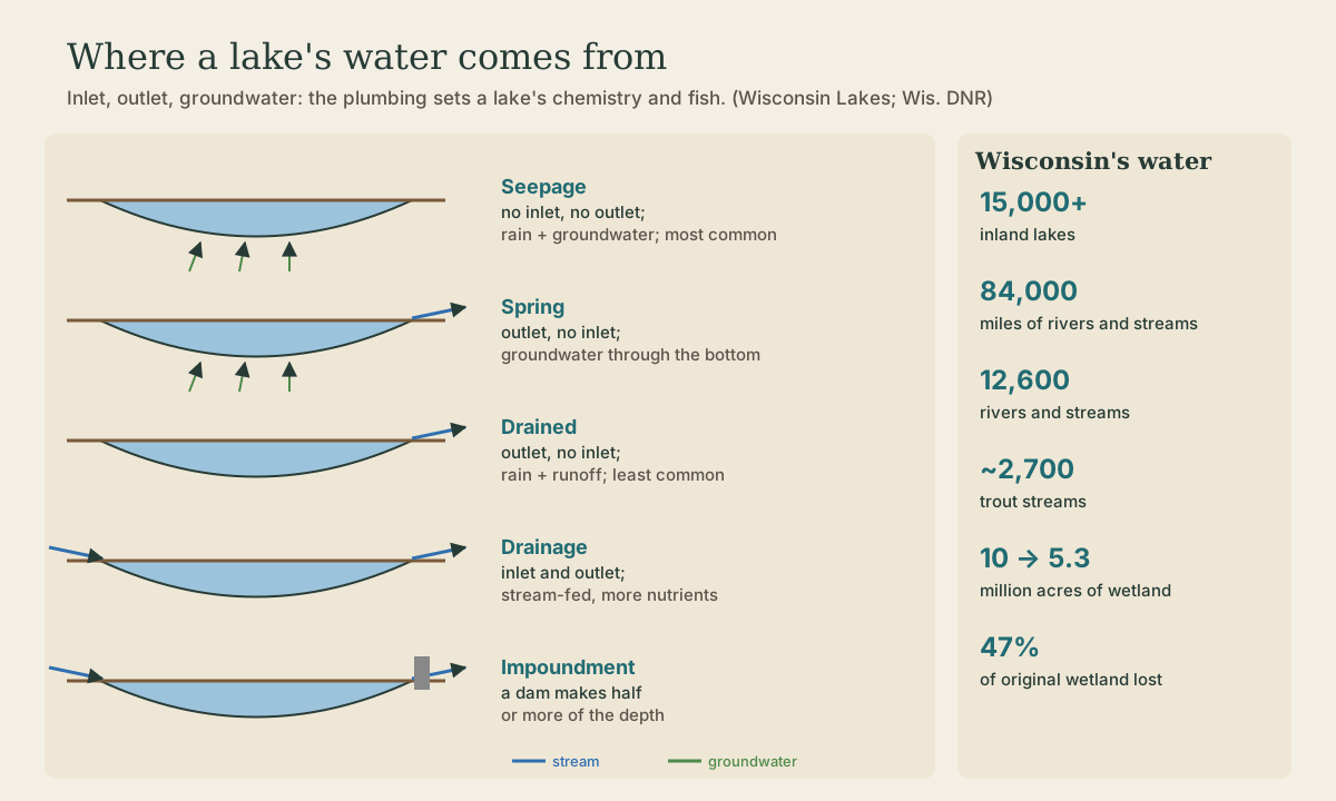
Lakes are sorted by their plumbing: whether they have an inlet, an outlet, and groundwater 2.
- Seepage lakes: no inlet or outlet. Their water comes from rain, runoff, and groundwater from right around them, so their levels rise and fall with the weather. They’re the most common type in Wisconsin, and with small drainage areas they’re often low in nutrients, with clear water and simpler fisheries 2.
- Spring lakes: no inlet, but an outlet. Groundwater flows in through the bottom. They’re the headwaters of many streams and fairly common in the north 2.
- Drained lakes: an outlet but no inlet and no groundwater, fed by rain and runoff; the least common type 2.
- Drainage lakes: an inlet and an outlet, fed mainly by a stream, and usually richer in nutrients than seepage or spring lakes; most major rivers have them along their course 2.
- Impoundments: a lake where a dam makes half or more of the maximum depth 2, like the flowages of the north and the millponds of the south.
The type predicts a lot: a nutrient-poor seepage lake in Vilas County and a stream-fed drainage lake in farm country can sit under the same sky and look nothing alike.
Quick check
Their levels rise and fall with rain and groundwater, and they’re often low in nutrients.
Layers and turnover
A deep Wisconsin lake doesn’t stay mixed. Water is densest just above freezing, at about 39 °F. In summer, the sun warms the surface, and that warm, light water floats on a cold, dense bottom layer, with a sharp temperature change between them, the thermocline. The bottom layer is cut off from the air for months, and its oxygen slowly runs down. In fall, the surface cools until it matches the water below, and wind mixes the whole lake top to bottom: fall turnover. Under winter ice the layers reverse, with the coldest water at the top, and in spring, after ice-out, the lake mixes again. Oxygen goes back to the bottom, nutrients come up, and fishing patterns change with it.
Playback is optional. If the player is unavailable, open the video at its source.
Quick check
Water is densest just above freezing, about 39 °F.
Rivers
Wisconsin has more than 12,600 rivers and streams across those 84,000 miles; about 32,000 miles flow all year, and the rest run only in spring and wet times 3. There are nearly 2,700 trout streams, more than 10,370 miles of them 3, most of them cold, spring-fed streams in the Driftless coulees and the north. The Mississippi runs about 200 miles along the state’s western edge 3.
Rivers here have been heavily dammed: about 4,700 dams, more than half privately owned 3. Taking dams out restores rivers. After four dams were removed in the 1990s, the Baraboo River became a 112-mile free-flowing stretch, one of the longest in the nation 3.
Wetlands
Wetlands are the marshes, sedge meadows, bogs, swamps, and fens between dry land and open water. They hold floodwater, filter runoff, and feed groundwater, and they’re some of the richest wildlife habitat there is.
Wisconsin once had about 10 million acres of them, judging by the extent of wet soils. The state’s wetland inventory, mapped from 1978–79 aerial photos, found about 5.3 million acres left, a loss of about 47 percent 4, mostly drained and tiled for farming or filled for building, and heaviest in the south. Horicon Marsh in Dodge County, the largest freshwater cattail marsh in the country, survived only after a failed attempt to drain it for farming.
.jpeg)
Quick check
Losses are heaviest in the farmed south.
What to take from this
Wisconsin has more than 15,000 lakes, 84,000 miles of rivers, and about 800 miles of Great Lakes shore. Lakes are sorted by plumbing: seepage (most common, no inlet or outlet), spring (groundwater, headwaters), drained (least common), drainage (stream-fed, richer), and impoundments. Deep lakes layer in summer and turn over in fall and spring. Nearly 2,700 trout streams run cold from springs, dams are coming out, and about 47 percent of the state’s wetlands are gone.
Lesson complete
Nice work.
Sources for this lesson
- 1Proclamation: Lakes Appreciation Month, July 2024. Office of the Governor, State of Wisconsin. 2024. verifiedWisconsin is home to more than 15,000 inland freshwater lakes, 84,000 miles of rivers and streams, and approximately 800 miles of Great Lakes shoreline.
- 2Lake Types. Wisconsin Lakes. verifiedSeepage lakes: no inlet or outlet, fed by precipitation and runoff supplemented by local groundwater, levels fluctuate, the most common type in Wisconsin, often less diverse fisheries and lower nutrients. Spring lakes: no inlet, an outlet, fed mainly by groundwater through the bottom; headwaters of many streams, common in northern Wisconsin. Drained lakes: no inlet, a continuous outlet, not groundwater-fed; the least common. Drainage lakes: inlet and outlet, mainly stream drainage, usually higher nutrients. Impoundments: half or more of maximum depth from a dam.
- 3River Facts and Resources. Wisconsin Department of Natural Resources. verifiedMore than 12,600 rivers and streams over 84,000 miles, about 32,000 miles flowing year-round; nearly 2,700 trout streams totaling more than 10,370 miles; the Mississippi runs about 200 miles along Wisconsin; about 4,700 dams, more than half privately owned; the Baraboo River's 112-mile free-flowing stretch after four dam removals in the 1990s; nearly 1,600 miles designated outstanding waters.
- 4Wisconsin wetlands: acreage facts. Wisconsin Department of Natural Resources. verifiedThe original land survey (1832-1866) mapped about 5 million acres of wetland but undercounted; soil scientists estimate about 10 million acres of wet soils, a better estimate of pre-settlement wetland. The Wisconsin Wetland Inventory, completed in 1985 from 1978-79 aerial photos, showed about 5.3 million acres remaining, a loss of about 47 percent.