Wisconsin's Ecological Landscapes
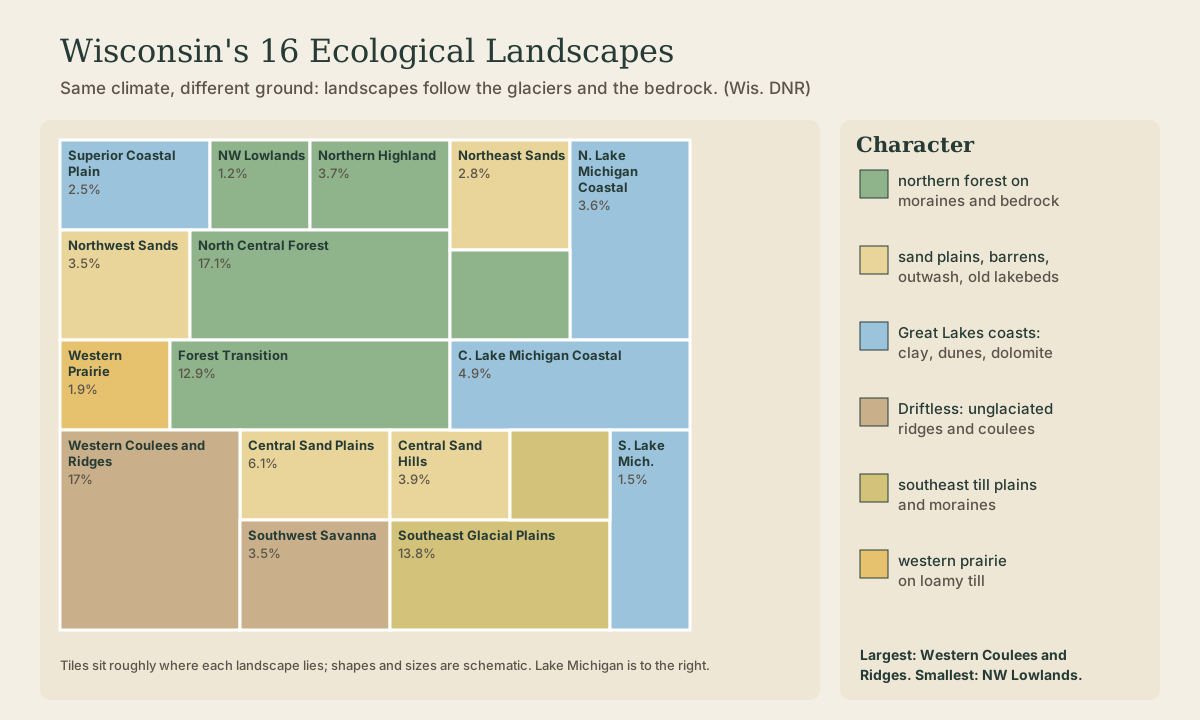
The Wisconsin DNR divides the state into 16 Ecological Landscapes, regions that share landforms, soils, bedrock, and natural communities. A tour by type: the northern forests on moraines over ancient igneous rock, the sand country of outwash plains and old glacial lakebeds, the Great Lakes coasts from Superior's red sandstone to Door County's dolomite, the unglaciated Driftless ridges and coulees (Western Coulees and Ridges is the largest at over 17 percent of the state), and the southeast's till plains. Why the same climate gives such different land: the glaciers and the rock underneath.
- 5 min
- 7 steps
- 3 questions
- Lesson 7 of 49
In this lesson
- What a landscape is
- The northern forests
- Sand country
- The Great Lakes coasts
- The Driftless
- The south and west
- What to take from this
Picking up where you left off.
What a landscape is
Drive from Platteville to Bayfield and the land changes under you: steep wooded coulees, then flat sand and jack pine, then rolling farmland on moraines, then dark hardwood forest full of lakes, then red clay bluffs on Lake Superior. The Wisconsin DNR names these regions Ecological Landscapes: 16 areas with different ecological attributes, used to decide which natural communities, habitats, and species each area is best suited to sustain 1.
What separates them is mostly underfoot. The climate changes gradually north to south, but the glacial history (what the ice left, or didn’t), the bedrock, and the soils change abruptly, and the plants and animals follow.
Quick check
The DNR uses them to decide what natural communities each area is best suited to sustain.
The northern forests
- North Central Forest (9,543 square miles, 17.1 percent of the state): end and ground moraines, pitted outwash, kettles, and steep ridges over ancient igneous and metamorphic rock buried under 5 to 100 feet of glacial drift 1. The hardwood and hemlock forest of the Northern Forest lesson.
- Northern Highland (3.7 percent): a gently rolling outwash plain with many kettle lakes, wetlands, and bogs 1, Vilas and Oneida county lake country.
- Forest Transition (12.9 percent): where northern forest meets southern farmland, all glaciated, with older (Illinoian) drift in its center 1.
- Northwest Lowlands (1.2 percent), the smallest, with a basalt ridge along the Douglas County fault 1.
Sand country
Where meltwater spread sand instead of leaving till, the land turned dry and open:
- Central Sand Plains (6.1 percent): a nearly level expanse of sand deposited in Glacial Lake Wisconsin by outwash from the melting ice 1, now jack pine, oak barrens, cranberry marshes, and irrigated potato fields.
- Central Sand Hills (3.9 percent): glacial moraines, including the Johnstown Moraine, the terminal moraine of the Green Bay lobe, and extensive pitted outwash 1.
- Northwest Sands (about 3.5 percent): the most extensive dry outwash system in northern Wisconsin, a pitted outwash plain of kettle lakes 1, home of the pine barrens.
- Northeast Sands (2.8 percent): outwash spread over the lowlands as the Green Bay lobe retreated 1.
Quick check
The same lake drained catastrophically and carved the Wisconsin Dells.
The Great Lakes coasts
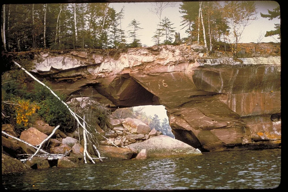
- Superior Coastal Plain (2.5 percent): late Precambrian sandstone cliffs and ledges along the Bayfield Peninsula and the Apostle Islands, red clay plains cut by deep stream valleys 1.
- Northern Lake Michigan Coastal (3.6 percent): the Niagara Escarpment, a ridge of Silurian dolomite, exposed as cliffs along the Door Peninsula and its islands 1.
- Central Lake Michigan Coastal (4.9 percent): Silurian dolomite under till plains and moraines, reworked by Glacial Lake Oshkosh 1.
- Southern Lake Michigan Coastal (1.5 percent): ground moraine, ridge-and-swale, dunes, and wave-cut clay bluffs, mostly under Milwaukee, Racine, and Kenosha 1.
.jpg)
The Driftless
- Western Coulees and Ridges (9,642 square miles, over 17 percent, the largest): highly eroded, unglaciated country of steep valleys and ridges on Cambrian and Ordovician sandstone and dolomite, with Precambrian quartzite in the Baraboo Hills 1.
- Southwest Savanna (3.5 percent): part of the Driftless Area, unglaciated for at least the last 2.4 million years, with broad open ridgetops above steep wooded slopes 1, once oak savanna and prairie.
The Driftless Area lesson covers why the ice went around this corner of the state.
Quick check
North Central Forest is a close second at 17.1 percent.
The south and west
- Southeast Glacial Plains (13.8 percent): till plains and moraines over limestone and dolomite, with the southernmost exposures of the Niagara Escarpment 1. Madison, kettle moraines, drumlins, and the best farmland.
- Western Prairie (1.9 percent): rolling glaciated till plain 1, Wisconsin’s share of the prairie that runs west into Minnesota.
What to take from this
Wisconsin’s 16 Ecological Landscapes are defined by what’s underfoot: glacial deposits, bedrock, and soils. Northern forests sit on moraines over ancient igneous rock; sand country comes from outwash and old glacial lakebeds (Central Sand Plains is Glacial Lake Wisconsin’s bed); the coasts run from Superior’s sandstone to Door County’s dolomite; the Driftless (Western Coulees and Ridges, the largest, over 17 percent) was never glaciated; and the southeast is till plain and moraine.
Lesson complete
Nice work.
Sources for this lesson
- 1Ecological Landscapes of Wisconsin. Wisconsin Department of Natural Resources. verifiedSixteen Ecological Landscapes with different ecological attributes and management opportunities. Examples: Western Coulees and Ridges, 9,642 sq mi, over 17 percent of the state and the largest, highly eroded unglaciated topography of steep valleys and ridges on Cambrian-Ordovician sandstone and dolomite, Precambrian quartzite in the Baraboo Hills; North Central Forest, 9,543 sq mi (17.1 percent), moraines and pitted outwash over igneous and metamorphic rock; Southeast Glacial Plains, 7,725 sq mi (13.8 percent), till plains and moraines over dolomite, the southernmost Niagara Escarpment exposures; Forest Transition, 7,279 sq mi (12.9 percent), entirely glaciated with older Illinoian drift in the center; Central Sand Plains, 3,420 sq mi (6.1 percent), lake and outwash sand from Glacial Lake Wisconsin; Central Lake Michigan Coastal (4.9 percent), Silurian dolomite and Glacial Lake Oshkosh deposits; Central Sand Hills (3.9 percent), Johnstown terminal moraine of the Green Bay lobe and pitted outwash; Northern Highland (3.7 percent), outwash plain with many kettle lakes, wetlands, and bogs; Northern Lake Michigan Coastal (3.6 percent), Niagara Escarpment cliffs on the Door Peninsula; Southwest Savanna (3.5 percent), Driftless ridgetops unglaciated for at least 2.4 million years; Northwest Sands (1,956 sq mi), the most extensive xeric outwash system in northern Wisconsin; Northeast Sands (2.8 percent); Superior Coastal Plain (2.5 percent), Precambrian sandstone cliffs on the Bayfield Peninsula and Apostle Islands; Western Prairie (1.9 percent), rolling till plain; Southern Lake Michigan Coastal (1.5 percent), ground moraine, dunes, and clay bluffs; Northwest Lowlands (1.2 percent), the smallest.