The Driftless Area
Why southwestern Wisconsin looks so different: the oldest surfaces in the state, never covered by the last ice, with deep valleys and steep ridges; the Cross Plains terminal moraine that marks its edge; Devil's Lake, held in its gorge by two moraine dams; and the sandstone stacks of Glacial Lake Wisconsin.
- 4 min
- 6 steps
- 3 questions
- Lesson 2 of 49
In this lesson
- No drift
- The edge: the Cross Plains moraine
- Devil’s Lake
- Glacial Lake Wisconsin
- Try it
- What to take from this
Picking up where you left off.
No drift
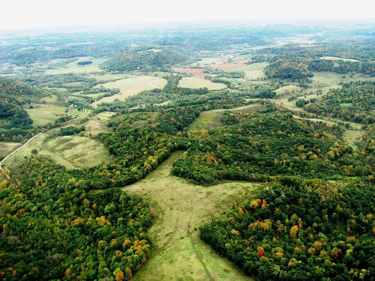
Drift is everything glaciers deposit: till, outwash, moraine. The Driftless Area of southwestern Wisconsin (and neighboring Minnesota, Iowa, and Illinois) has none from the last ice sheet. “Unquestionably the oldest surfaces in Wisconsin are those in the classical Driftless Area of the southwest,” Black wrote; it “was not invaded by ice of the last two major substages, the older of which covered most of the rest of the state” 1.
.jpg)
So instead of the lakes, wetlands, and rolling hummocks the ice left elsewhere 2, the Driftless Area is a landscape carved by running water over a very long time: flat-topped ridges, steep, deep valleys (coulees), bluffs, springs, and cold, clear trout streams. There are almost no natural lakes.
Black also noted that geologists had long found evidence that earlier ice reached farther west than the last, so “driftless” is about the last glaciations, not all of them 1.
Quick check
The Driftless Area has the oldest land surfaces in Wisconsin.
The edge: the Cross Plains moraine
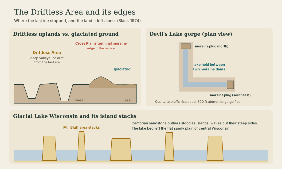
About 10 miles west of Madison, near Cross Plains, the last ice sheet “ground to a halt on the southwestern Wisconsin uplands, marking the east boundary of the Driftless Area with a young moraine” 1. Stand on that terminal moraine and the contrast is plain: hummocky glacial ground to the east, deep, smooth-sided valleys to the west. Cross Plains is one of the Ice Age Trail’s reserve units 3.
Devil’s Lake
In the Baraboo Range, Devil’s Lake sits in a steep-walled, L-shaped gorge whose floor lies about 500 feet below the rolling upland near 1,400 feet 1. The bluffs are ancient Precambrian quartzite.
What holds the lake in is glacial: the gorge is plugged at both its north and southeast ends by end moraine, part of the Johnstown Moraine that traces the front of the Green Bay Lobe 1. Black called the pair of moraine plugs, with a well-defined end moraine running for miles from them, “certainly one of the few best such features to be found anywhere in the world” 1. West of the moraine, on the upland, is ground the last ice never reached.
Quick check
Black called the paired moraine plugs and the moraine running from them one of the best such features anywhere.
Glacial Lake Wisconsin
During the ice advances into central Wisconsin, a large meltwater lake, Glacial Lake Wisconsin, spread across the center of the state, held in by the ice front. Its flat, sandy bed is the plain of central Wisconsin today 1.
Rising abruptly from that plain near Camp Douglas are Mill Bluff and its neighbors (Bee, Camels, Round, and others): yellowish Cambrian sandstone buttes, spires, and towers. A geologist calls them stacks: their steep sides were “carved by wave and current action in Glacial Lake Wisconsin, where they stood as isolated islands” 1. They are outliers of the sandstone upland that continues to the south and southwest 1. Mill Bluff is also an Ice Age Trail reserve unit 3.
Playback is optional. If the player is unavailable, open the video at its source.
Quick check
They’re outliers of the Cambrian sandstone upland.
Try it
Drive west from Madison on U.S. 14 past Cross Plains and watch the land change at the moraine. Then visit Devil’s Lake and find both moraine plugs from the trail map, and stop at Mill Bluff State Park on the way north to climb a stack that was once an island.
What to take from this
The Driftless Area of southwestern Wisconsin has no deposits from the last ice and the oldest surfaces in the state: ridges, deep coulees, springs, and almost no natural lakes. The Cross Plains terminal moraine, about 10 miles west of Madison, marks its eastern edge. Devil’s Lake fills an L-shaped quartzite gorge plugged at both ends by end moraine. Mill Bluff and its neighbors are sandstone stacks carved by waves when they were islands in Glacial Lake Wisconsin.
Lesson complete
Nice work.
Sources for this lesson
- 1Robert F. Black. Geology of Ice Age National Scientific Reserve of Wisconsin (NPS Scientific Monograph No. 2). National Park Service. 1974. verifiedThe Driftless Area of the southwest has the oldest surfaces in the state and was not invaded by the last ice; the Northern Kettle Interlobate Moraine formed between the Green Bay and Lake Michigan lobes, with kettles, moulin kames (conical hills of drift deposited under the ice where meltwater poured down a shaft), eskers, crevasse fills, and pitted outwash, lacking integrated drainage, culminating at 1311 ft at Parnell tower; about 5000 drumlins in southeastern Wisconsin, streamlined hills with long axes parallel to ice movement, some ridges 3 to 4 miles long; the Cross Plains terminal moraine about 10 miles west of Madison marks the east boundary of the Driftless Area; Devils Lake in the Baraboo Range lies in an L-shaped gorge about 500 ft below the uplands, plugged north and southeast by end moraine of the Johnstown Moraine; Mill Bluff and nearby bluffs are Cambrian sandstone stacks carved by waves when they stood as islands in Glacial Lake Wisconsin.
- 2Ice Age Geology. Wisconsin Geological and Natural History Survey. verifiedThe last glacier began advancing into Wisconsin about 31,500 years ago and expanded for 13,500 years; warming began about 18,000 years ago and the ice took another 7,000 years to leave northern Wisconsin, about 11,000 years ago; lobes: Lake Michigan, Green Bay, Langlade, Wisconsin Valley, Chippewa, Superior; the outermost limit is marked by a conspicuous ridge of glacial debris, and the many lakes and wetlands and irregular landscape of eastern and northern Wisconsin come from the last glacier.
- 3Ice Age National Scenic Trail. National Park Service. verifiedA 1,200-mile trail across Wisconsin following glacial and geologic features, through the ancestral lands of 15 Tribes; reserve units include Kettle Moraine, Campbellsport Drumlins, Chippewa Moraine, Two Creeks Buried Forest, Devil's Lake, Cross Plains, Horicon Marsh, Mill Bluff, and Interstate State Park.